Descripción
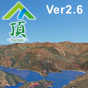
新バージョン登場。 山岳立体マップ[頂] (奥多摩)エリアのPC版です。 最新情報や他エリアのご購入は「山岳頂」で検索します。
[頂]は、インドア・アウトドアどちらも使える山アプリです。 365日 山歩き。 携帯電波の届かない場所でも地形を立体表示可能。 これまで無かった、山の凹凸に向き合った山アプリです。 ・イメージトレーニング/地形把握 ・計画立案 ・GPS現在地取得(モバイル版) ・山座同定 ・登山追体験 等にお使いください。 ※:「北ア 立山・無料版」、「陣馬・高尾 無料版」でお試しできます。 ※:最新情報は「山岳頂」で検索して[頂]のホームページにアクセス。 ※:カスタマイズはご相談ください。
A la gente también le gustó
Opiniones
Artículo
sobre 頂(奥多摩)
Advertisement
Top Descargas
- 1
GPX viewer and recorder
 Gratuito
 - 2
Maps for Gmaps
Gratuito - 3
Mapas de Windows
Gratuito - 4
Open with Maps
Gratuito - 5
COM-MAP
Gratuito - 6
Earth View - Map 3D
Gratuito
Tendencias en aplicaciones
- 1
QRCode Helper
Gratuito - 2
AtomicClock • NTP Time
Gratuito - 3
Advanced Installer Express
Gratuito - 4
iPhoto Transfer
10 - 5
Focus X2
Gratuito - 6
AtWin
Gratuito
Aplicaciones mejor valoradas
- 1
GPX viewer and recorder
Gratuito - 2
Maps for Gmaps
Gratuito - 3
Mapas de Windows
Gratuito - 4
Open with Maps
Gratuito - 5
COM-MAP
Gratuito - 6
Earth View - Map 3D
Gratuito
Juegos mejor valorados
- 1
Minecraft Launcher
Gratuito - 2
Angry Birds 2
Gratuito - 3
Roblox
Gratuito - 4
Hidden City: Aventura de objetos ocultos
Gratuito - 5
Sherlock: Juego de objectos ocultos
Gratuito - 6
Roger That: juegos de merge! Aventuras en la isla
Gratuito